The Himalayas have the third largest deposit of ice and snow in the world, after Antarctica and the Arctic. The Himalayan range encompasses about 15,000 glaciers, which store about 12,000 km 3, (3,000 cubic miles) of fresh water. Its glaciers include the Gangotri and Yamunotri (Uttarakhand) and Khumbu glaciers (Mount Everest region), Langtang glacier (Langtang region) and Zemu (Sikkim).
Owing to the mountains’ latitude near the Tropic of Cancer, the permanent snow line is among the highest in the world at typically around 5,500 meters (18,000 ft). In contrast, equatorial mountains in New Guinea, the Rwenzoris and Colombia have a snow line some 900 meters (2,950 ft) lower. The higher regions of the Himalayas are snowbound throughout the year, in spite of their proximity to the tropics, and they form the sources of several large perennial rivers, most of which combine into two large river systems:
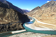
The western rivers combine into the Indus Basin, of which the Indus River is the largest. The Indus begins in Tibet at the confluence of Sengge and Gar rivers and flows southwest through India and then through Pakistan to the Arabian Sea. It is fed by the Jhelum, the Chenab, the Ravi, the Beas, and the Sutlej rivers, among others.
Most of the other Himalayan rivers drain the Ganges-Brahmaputra Basin. Its main rivers are the Ganges, the Brahmaputra and the Yamuna, as well as other tributaries. The Brahmaputra originates as the Yarlung Tsangpo River in western Tibet, and flows east through Tibet and west through the plains of Assam. The Ganges and the Brahmaputra meet in Bangladesh, and drain into the Bay of Bengal through the world’s largest river delta,the Sunderbans. The easternmost Himalayan rivers feed the Ayeyarwady River, which originates in eastern Tibet and flows south through Myanmar to drain into the Andaman Sea.
The Salween, Mekong, Yangtze and Huang He (Yellow River) all originate from parts of the Tibetan Plateau that are geologically distinct from the Himalaya mountains, and are therefore not considered true Himalayan rivers. Some geologists refer to all the rivers collectively as the circum-Himalayan rivers. In recent years, scientists have monitored a notable increase in the rate of glacier retreat across the region as a result of global climate change. For example, Glacial lakes have been forming rapidly on the surface of the debris-covered glaciers in the Bhutan Himalaya during the last few decades. Although the effect of this will not be known for many years, it potentially could mean disaster for the hundreds of millions of people who rely on the glaciers to feed the rivers of northern India during the dry seasons. Some of the lakes present a danger of a glacial lake outburst flood. The Tsho Rolpa glacier lake in the Rolwaling Valley is rated as the most dangerous in Nepal.

